River Restoration and Resiliency Post-Flood

River restoration is a challenge–particularly in an urban environment where the river is highly impacted and the river banks are often highly developed. Project goals and objectives must be carefully stated and project constraints and limitations must be carefully defined and evaluated. S2o has begun work on a $2.5 million restoration of the St. Vrain river following the worst flood in recorded history for this valley. The starting point of this project is the most developed, confined, and, from a design standpoint, challenging, reaches in the river. The goal of the project? To minimize flood impacts and increase resiliency in the river by recreating a healthy river- and eco-system.
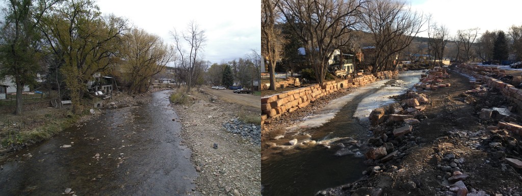
What is a healthy river and eco-system: one good way to understand what a healthy, resilient river looks like is to understand what a typical unhealthy river looks like. Fortunately, we have, or had, this type of area in Town located downstream of the 5th Avenue Bridge on the North Fork of the St. Vrain. This area was a great example of a typical urban and highly impacted river before the flood. In this area human development has severely encroached on the river to the point where all of the flow is confined between two steep banks. This was done by landowners literally filling the floodplain with earth to build houses and streets that were positioned right along both sides of the main channel with very little breadth left for expansion during a flood event. In order to handle moderate flooding events the people who built on both sides of the river built higher walls with fill at higher elevations so that more water translated to more depth. This higher depth translated to higher velocities during flood events, and a channel that was largely denuded of habitat or complexity due to scour and excavation. The North St. Vrain in this reach had become a square-bottomed ditch.
By comparison, a healthier river is one in which the river is a complex system with a defined low-flow channel, a defined river channel, some sinuosity, and room to expand into a floodplain. The floodplain is a riparian area that typically includes a wealth of native trees and plants on a low bench near the river. As the river rises, energy is diffused into this area which is important. There are also a variety of species that thrive in this ecosystem and rely on regular flooding. Each of these components plays a role in healthy river function.
In the area downstream of 5th avenue, which is an area that can be viewed in the coming weeks as it is developed. You will see that S2o has designed just such a multistage river and are building it now. In this instance the multi-stage river is wedged within a fairly tight space yet it will provide each of these components. The process of designing and implementing this project included:
- a) An evaluation of the watershed at varying reach scales to define priorities and objectives for this particular reach within the context of the entire river system.
- b) A conceptual design process in which varying solutions to meet these objectives were defined and evaluated until an acceptable design was reached (this process included a phase of public process which all of the town was invited to and invited to pose both questions and comments).
- c) A computer modeling phase in which extensive floodplain modeling was completed to ensure that no one’s home or property was negatively impacted by the project and that velocities and depths met design objectives.
- d) Several stages of design including grading, wall plans, design of the river, design of the habitat, and planting plans. As a part of this process the project received all required permits to verify that these plans met all the regulatory requirements for doing this work in a river in Colorado.
One of our concerns is about losing trees and riparian habitat along the river. The design team took all care possible to preserve as much plant life as possible and is replanting extensively to replace and improve the trees and riparian habitat lost. The good and bad news is that, over the last 50-100 years, the confined and unhealthy river has still seen tree growth and riparian growth along its banks. Many of these trees and plants are rooted in the same fill used to encroach upon the river years ago. In order to remove this fill and open the river up to create a healthy river system, these trees and plants need to be removed. Without this, we make only band-aid improvements that do not protect the Town nor improve stream health. We will replant native trees (over 10,000 trees or plants are being planted) as part of this project, once a healthy river system has been re-created. Please know that tree removal is not done lightly, but that extensive survey, design, computer modeling, and analysis was been completed prior to making these choices. Additionally, an arborist has been consulted when in doubt about individual trees and choices are then made based on this information.
Additionally, S2o has worked with consultants to implement fish habitat in microsystems along the river. The larger pool/riffle sequence has been further modified with imported boulders and superficial grading to create pools, riffles and velocity barriers in the river. S2o has also added woody debris and classic fish habitat structures such as bendway weirs, j-hooks, cross-veins, and deflectors to further increase the habitat functionality of the project.
The completed river will have less flood risk, be more resilient, will decrease velocities and stress on the river, and will provide a thriving eco-system for both in-stream and riparian habitat. This is a project that meets and exceeds the goals laid out in Lyons Long Range Recovery Process and one that provides us with a Town that will better endure the next flood.

